Repairing a Dam in Zambia, an exotic and unusual mission. Didier Aveline, chief topographer and AutoCAD and AutoLISP Expert Elite, tells us about his last mission in Africa on the site of one of the biggest dams in the world.
When the brave Michel de Montaigne* wrote ” Traveling keeps you young”, he probably didn’t imagine the life span of this quote which has entered the common language. Certainly youth is a state of mind but if we were to reduce life to a day we could say that I arrive at the end of the afternoon and so for what travel represents I would say that it is meeting other humans that attracts me more than the search for unknown landscapes, both form the heads and tails of the coin “travel” no matter which side the coin falls on it is a winner. And I didn’t know that there was so much of the unknown when a friend of mine, a director in a large public works company, asked me about my professional availability in the months to come. At first I chose to answer evasively, not knowing the content of the proposal, but very quickly I became more feverish when I heard the name of the country in which I was proposed to work: Zambia.
I pass quickly on the multiple hassles triggered by the Covid as well as the journey towards these southern lands which are not very accessible from France without making multiple changes of planes to end up arriving directly in Lusaka capital of Zambia. A driver is noticed with a sign with my name and the logo of the company, it allows me to avoid the multiple offers of cabs, official or clandestine, which always propose faster transport than the colleagues, I know by experience that once in the car it is another song which is heard and it is necessary to negotiate the destination or the fuel. Especially that it is not the door next door where I go, five hours of road are necessary to join the point of appointment. Although it is in the capital of the country, the airport does not have a wi-fi network and I ask the driver to drive me in town to the office of the company to warn my relatives of my arrival in one piece, because in France we worry about me without questioning if there is network or not so much we are used to be “connected” wherever we are. This being done and the relatives reassured, half an hour later we are on the road due south with the Kariba dam in sight.
Zambia is a country whose history is linked with the British domination and in addition to the language many things are different, starting with the traffic which is carried out on the left side of the road, the driver being installed on the right behind his steering wheel. With the tiredness of the trip I doze off and every time I wake up after an untimely hit of the steering wheel or a pothole bigger than the others, I am startled to discover myself on the left, in the driver’s seat, by reflex I look for the steering wheel to put me back on the right lane. New habits are quickly acquired by necessity and I would no longer have to suffer from this inconvenience, the fatigue of the trip explains the comatose state that makes me react so promptly.
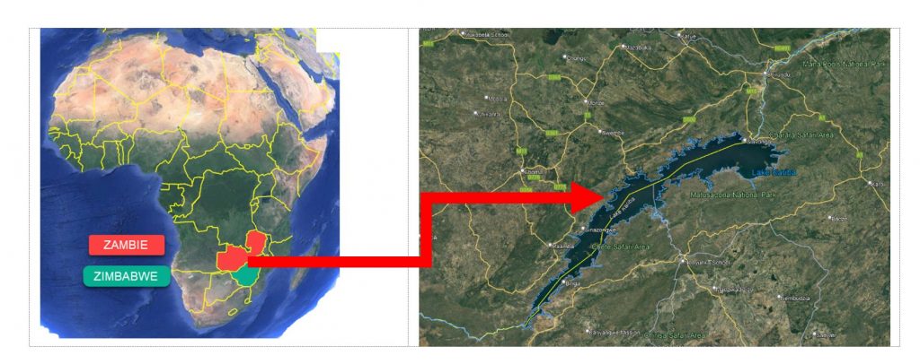
The construction site is located at the Zambia/Zimbabwe border, and for a good reason, because it is a dam on the Zambezi River, this river being the natural border between these two countries. Each bank has its own power station and uses the power of the water to turn huge generators producing the electricity necessary for a good part of the consumption of both countries.
Building a dam on a border with two symmetrical power plants seems like a great political idea, using a natural resource in common as a result of a joint investment seems like an ideal, even idealistic, but the truth is quite different, in fact this dam was built in the 60s of the last century at a time when Zambia as well as Zimbabwe did not exist as independent countries.
To make a long story short, Southern Rhodesia, a British colony, split into Zimbabwe and Zambia in the 80’s. There is no question of politics here, just a statement explaining that the border dam was not born from an extraordinary agreement between two countries but is part of a legacy from a single political entity. It is a pity because the utopia of an agreement was beautiful but unfortunately made impossible by the egocentric bias of each political leader.
This dam is one of the biggest in the world, with a height of one hundred and twenty-eight meters and a width of five hundred and twenty meters, it holds back a lake of two hundred and twenty kilometers long for a volume of one hundred and twenty cubic kilometers, figures that are very difficult to apprehend because of their exceptional character.
For the record, Lake Geneva is seventy kilometers long!
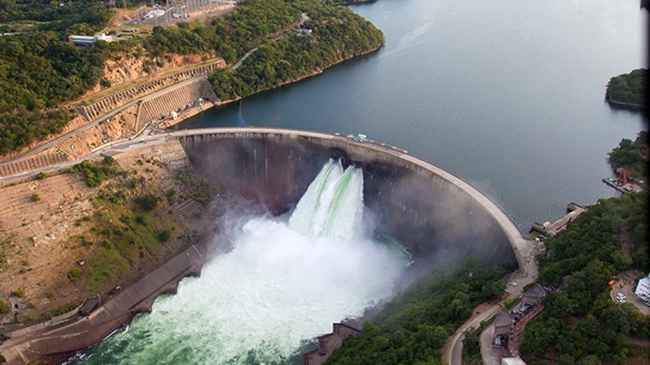
View from the sky :
The time has not been very kind to this structure, without arguing about the initial studies or maintenance, it turns out that the time has undermined the soil downstream of the dam. The dissipation basin has not resisted the formidable destructive power of the water when opening the gates to discharge the reservoir during the adjustment of the necessary level during the rainy season.
These works of strategic importance cannot be supported by the countries that own the structure and the World Bank has been called upon to do so.
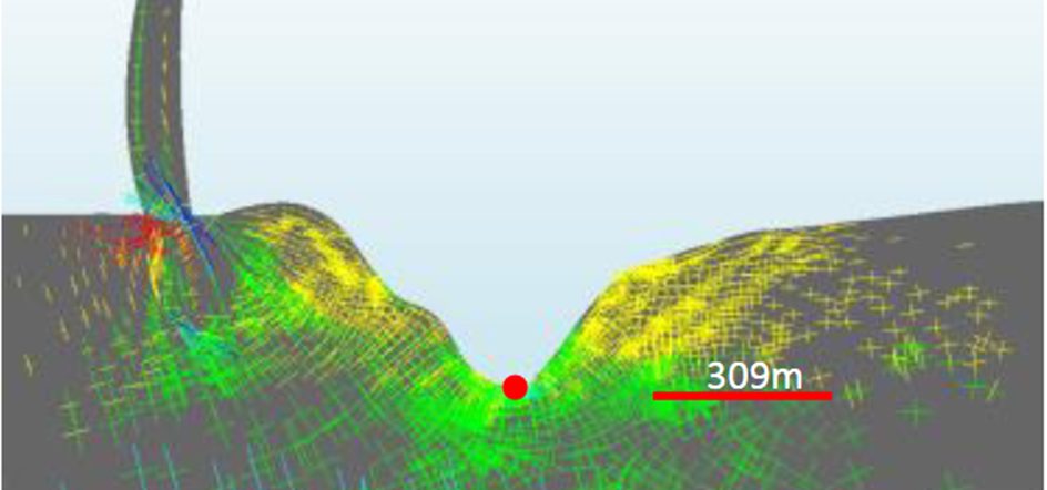
Illustration of the artificial waterfall that undermined the receiving soil and caused the rock to burst, resulting in the creation of an eighty meter deep pit downstream of the dam.
A cross-section in the direction of the river illustrates perfectly the need to fill in and reinforce the soil of the dissipation basin.
The principle is to create a cofferdam (temporary dam) to isolate the area from the pit. Then, pump these hundreds of thousands of cubic meters to dry it out. Create a helical track to descend to the bottom of the pit, once at the bottom reinforce the rock with layers of concrete and continue upwards, without however filling the pit completely with concrete. Eventually the cofferdam will be dismantled and everything will be as before, but stronger. None of this gigantic work will be visible from the surface because the water will return and flood the reinforcing concrete layers.
These are the main lines of the work to be carried out, I will not go into detail about the realization of this construction site because it is not the purpose of this text, I am just talking about an exceptional construction site in an exceptional environment.
Fortunately, an international (even worldwide) exchange tool is at our disposal to carry out the hundreds (thousands) of drawings, sections, simulations, auscultations, operating procedures, preliminary estimates and quantities… This tool, as you may have guessed, is AutoCAD, with which teams from different trades are able to collaborate in a single format. Each engineering unit uses its own “trade” application, geologists, hydraulic engineers, surveyors, concrete engineers, etc., but they all end up using AutoCAD to transmit their data. Certainly, my knowledge of the software allowed me to settle into the project in a few days, by opening the study files and studying the proposed variants, I was quickly in “efficient” mode.
I couldn’t resist the urge to stretch my fingers by writing a few AutoLisp routines that should last in their uses after my departure. Indeed, repetitive tasks are by definition tiring and time consuming, automating them via AutoLisp is the best way to work fast without harming quality by avoiding the boredom inherent to multiple repetitions in the work and possible typing errors specific to humans who will confuse 96 and 69 after a certain time of typing. Since AutoLisp is not human, it is not affected by this uncertainty and will always use the right data for a consistently correct result.
For example, a 3D polyline representing the path of a pumping pipe, locating in one click the highest and the lowest point of this polyline and displaying the difference in altitude is a job perfectly doable by hand by analyzing the altitudes but typically AutoLisp will do it for us without ever being wrong whatever the length of the polyline or the number of vertices, this is only an example of course, it is the use of the drawing and the desires of the colleagues that will guide the apprentice developer.
Note of the first line: *adage attributed to Montaigne, I did not reread his “essays” before writing this paper so I quote it from memory.