Executive summary
- AFRY, a sustainable solutions leader and one of Europe’s largest engineering and design firms, was chosen by Swedish local authorities to address the growing population by maximizing available space and adding new buildings into existing neighbourhoods.
- For the proposed development at Fjällbogatan, AFRY faced the task of not only mitigating flood risks but also finding an effective way to evaluate multiple design iterations and layouts early on. This was essential to assess the impact of each iteration on the site’s environmental and commercial requirements right in the planning phase, while keeping time and budgets in check.
- Using Autodesk Forma, planners were able to quickly create interactive 3D models, improving efficiency and reducing environmental risks, much earlier than in a traditional planning process.
- With repeatable elements and powerful analyses, Forma enabled faster design iteration, data-informed decisions, and better communication with stakeholders. The team at AFRY was hence able to give the municipality the full saleable area they wanted. They even managed to increase the capacity of the complex from 100 to 108 apartments without compromising on the architectural vision or the investment potential of the overall program.
A leader in sustainable solutions, AFRY is one of Europe’s largest engineering and design firms. Offering services across markets including infrastructure, industrial, and decarbonisation initiatives, its 19,000-strong team works on projects in more than 100 countries around the world. And with such a strong focus on environmentally conscious developments, AFRY was the natural choice for Swedish local authorities looking to add buildings into existing neighbourhoods.
The Fjällbogatan development
With a growing population, the municipality of Gothenburg has been maximising available space by developing suburban sites into new residential and commercial opportunities. Working closely with AFRY, officials proposed a development at Fjällbogatan and have been able to address challenges identified early in the planning process.
Adding new buildings to a residential neighbourhood can be an involved undertaking comprising multiple steps, teams, and stakeholders. Balancing the needs of the existing community with commercial and legal requirements is one of the most interesting aspects of city planning, and one that quite often goes through a process of iteration in the early stages. For the Fjällbogatan apartments and housing project, creating efficiency during the planning stage became vital to prevent costly delays to the scheme. By using Autodesk Forma, planners were able to iterate quickly and efficiently through site designs to produce the best possible layout for the site.
“We’re always looking for new tools and new ways to increase efficiency. Autodesk Forma has improved our early-stage design processes.”
Maryam Sepehr, Architect at AFRY
Using the available space
The municipality of Gothenburg owns several sites across the city, with many sandwiched between existing developments and established areas. “There was a desire from the real estate department of the municipality to develop an area at Fjällbogatan,” explains AFRY city planner, Maryam Sepehr. “Their approach would be to pre-approve a site design and sell the opportunity to a commercial developer for completion.”
Traditionally, city planning is a time consuming process. Once the site is defined, a 2D design is produced and then translated into 3D. Once this layout and scope is confirmed, surveyors and acoustic engineers will examine the plan and the real-world location, and report on its suitability. Any modifications mean going back to the 2D design and working through the whole process again. “It can take a long time,” comments Maryam. “A lot of a project’s budget can get consumed in the iterations during the planning phase.”
Critical corrections
For the Fjällbogatan development, a stormwater survey identified a critical problem. Situated downstream of a large catchment area, the site is inherently vulnerable to flooding. This vulnerability is further exacerbated by the proposed amount of building area in the development plan – the increase in impervious surfaces, such as concrete and asphalt, associated with the new construction would lead to a substantial rise in the volume of runoff, particularly during heavy rainfalls. Coupled with the existing drainage system’s inability to handle such volumes, this increase in runoff posed a significant risk of rain water overflowing onto adjacent streets.
“This situation not only threatens the new development but also endangers the surrounding areas,” says Maryam. “The initial proposal for the development did not sufficiently address these flood risks. In light of Sweden’s strict flood management regulations, it became necessary to revise the development plan.”
From a commercial perspective, the proposal had become less enticing to prospecting developers.
Early-stage design iterations
New developments come with their fair share of challenges. For the Fjällbogatan site, its narrow nature and proximity to two-storey row houses restricted AFRY’s options to address the concerns raised by the stormwater survey – reducing the building footprint and adding height simply wasn’t possible. “The neighbourhood would have objected and the whole project would have been put at risk,” suggests Maryam. “We needed a way forward to optimise the opportunities afforded by the space we had.”
It’s during the early stages of a project that potential issues are raised and overcome, ensuring that, once building commences, no surprises come to light. The problem with the traditional approach of iteration is that this first stage can take a long time, with new surveys and reports required for each update. Clients often put limits on how many avenues are explored due to the possibility of delays and the budget black hole they create. “Often we’re only going through four or five versions of what we could do,” adds Maryam. What AFRY needed was a way to test dozens of possible layouts, then understand their impact on the site and its environmental and commercial requirements without having to commission more surveys – work that could take weeks or even months.
Data-driven digital efficiencies
Autodesk software has been a part of AFRY’s design process for decades. Revit, AutoCAD, and 3ds Max are all found somewhere within the business. “We’re always looking for new tools and new ways to increase efficiency,” says Maryam. “Last year I started looking at Autodesk Forma as a way to improve our earlystage design processes.”
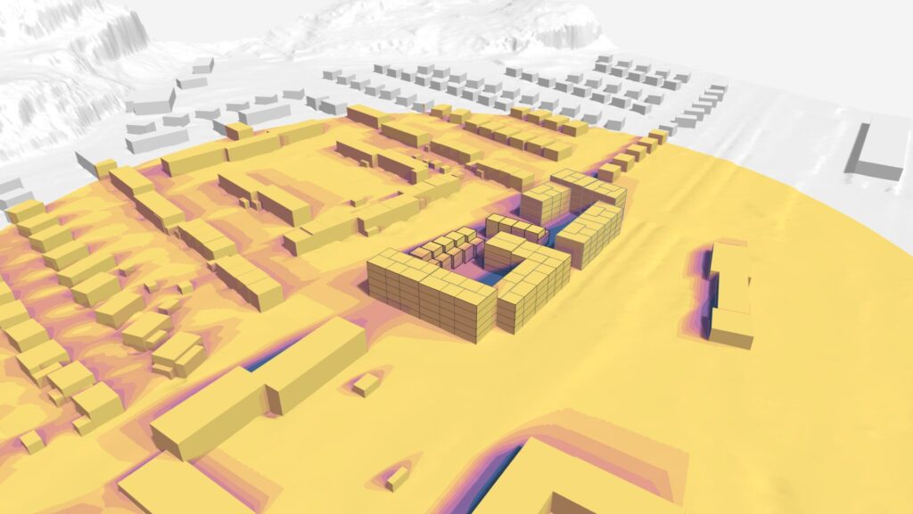
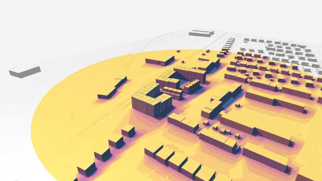
Forma is a cloud-based solution for early-stage planning and design. By connecting to databases around the world, it’s capable of fetching a 3D terrain model in minutes – much faster than creating a site model from scratch.
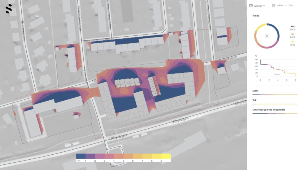
“We’re able to designate the site area on the digital landscape and immediately see the impact of the surrounding environment and buildings based on real data. What’s particularly powerful is how we can then measure the impact of noise, wind, and solar shading on our ideas – all the aspects that we would normally need to wait for a survey to detail.”
Maryam Sepehr, Architect at AFRY
By equipping planners with the tools to create interactive 3D models quickly, Forma is helping to drive efficiencies and reduce risks much earlier than in a traditional process. Generated, repeatable elements give architects the ability to design faster and iterate more easily, and powerful analysis tools grant access to accurate information about the impact of the building on its surroundings, and vice versa. It helps to ensure design quality and communicates concepts clearly, building confidence in a proposal with clients and investors.
“We were able to use Forma to come up with an effective way to position all our planned buildings. It meant that we could analyse the proposals ahead of time and helped guarantee the best solution.”
Maryam Sepehr, Architect at AFRY
Optimising opportunities
In its use of Autodesk Forma, the AFRY team was able to give the municipality the full saleable area they wanted, and even managed to increase the capacity of the complex from 100 to 108 apartments. Full residential facilities, commercial units, and recreational areas were all included without compromising on the architectural vision or investment potential of the overall program.
“Forma has given us the ability to not only design the optimum site layout, but to communicate that to all stakeholders in the clearest and most engaging way possible.”
Maryam Sepehr, Architect at AFRY
The result is a site plan that sailed through its initial review with local authorities and has moved swiftly on to a citizens feedback process. “We’re confident that we’ll be able to progress on the plan as submitted,” concludes Maryam.