You probably have some idea of the capability of 3D scanners to convert actual objects into files that can be 3D printed or even designed around. What you may not be aware of, is just how easy it is for someone to develop a 3D model of a building, a landscape, even a statue, using only an off the shelf drone and some free software.
There are many companies out there that advertise their drone technologies for surveying uses in building construction. This has become a useful tool to many civil engineers, and its usefulness is growing still. When a drone is used for these purposes, it uses its GPS data and camera data to develop an elevation point cloud for a specific site. The first problem you might foresee is tolerances on survey data. This has traditionally been a problem for most low cost surveying solutions – but drones have now launched beyond this limitation. A typical drone survey with the use of a GoPro camera on a gimbal and GPS positioning can achieve point cloud accuracy within 3 centimeters. This level of accuracy is done all without ground control points as well.
While point clouds for survey data is a form of 3D model, it’s not specifically the type of 3D model we’re focusing on. Say, for example, you wanted to generate a 3D model of a sculpture so you could create scale models through additive manufacturing. If the sculpture was small enough, you could use a 3D scanner or even your smartphone if fidelity isn’t an issue. If the sculpture was something like 50 feet tall, a handheld 3D scanner isn’t going to work well. This is where your common everyday drone comes into play.
By setting a drone’s camera to take still photos every 2-3 seconds and making slow continuous passes around the object or building, you can start collecting all of the data that you need. If it sounds simple, it’s because it is. Other than some learning curves on the backend, anyone that owns a drone can start collecting data to make a 3D model of whatever structure they want. Variables like lighting and glares do affect the accuracy of the data, so it’s typically a good idea to go out on an overcast and calm day.
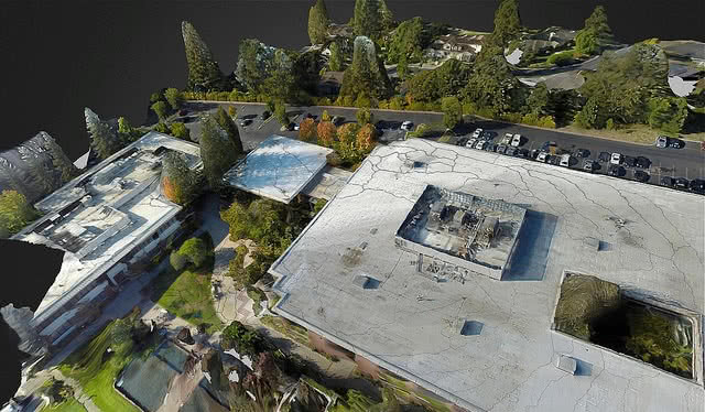
Once you have your data collected, it’s time to feed it into a stitching program. There are plenty of free programs out there that will take drone photographs and convert them into 3D models. Essentially, these programs take all of the photos and determine their relation to the other photos, then lay them out in an actual 3D pattern. From these 3D arranged photos, the stitching program will generate a point cloud as dense as possible from the given images. Most programs that generate this point cloud will output a file that needs to be cleaned up and smoothed out in order to print it directly to a 3D printer.
This process of 3D scanning from drone imagery is becoming more commonplace with artists and modelers. It gives the capability to accurately preserve or scale a historical monument or maybe just your house. As drones continue to mesh with the 3D design and manufacturing realm, capabilities for engineers will only expand. Sometime soon, a structural engineer may even be able to run accurate seismic or wind loading simulations on a 3D model generated by a drone – further connecting the real world to the virtual.

(0)