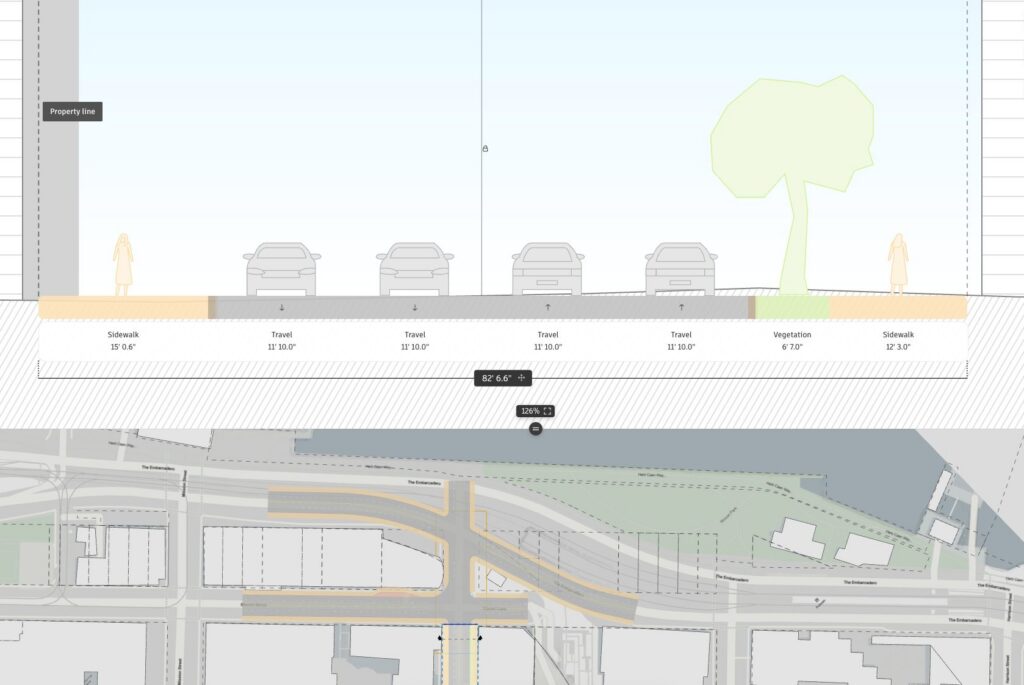
At Autodesk University 2026, we’re introducing Forma Street Design — the newest addition to Forma’s design solutions. Forma Street Design is a cloud-based street design software that civil engineers and transportation planners use to lay out and iterate on streets in real site context during early-stage design, part of Autodesk Forma, the AEC industry cloud. Forma Street Design is currently in development, but starting today, you can join the waitlist for closed beta.
This is only the beginning. We’ve been building Forma Street Design with a group of pilot engineering firms, including independent Autodesk Expert Elites, testing it on real projects. Our closed beta is where that opens up to the wider engineering community.
If you join the waitlist, you’re not signing up to try a finished product. You’re signing up to be among the first people to use it, tell what works well and what needs improvement, and help shape where Forma Street Design goes next for engineers.
What is Forma Street Design?
Forma Street Design helps civil and transportation teams explore street design changes live — from alignments and curve radii to lane widths — so you can spot issues, compare options, and agree on a direction sooner. Once you’re aligned, continue the design in Civil 3D without rebuilding it from scratch, which lowers the risk of painful changes later.
With Forma Street Design, you can:
Design directly in context. Import GIS layers, terrain, adjacent buildings, and property boundaries in minutes instead of hours.
Make changes in an instant. Add a bus bulb-out in one click, move an alignment, use swept path analysis powered by Autodesk Vehicle Tracking, and explore plan and section at once.
Continue the design in Civil 3D. Once you’re confident in your design direction, move directly into Civil 3D for detailed engineering without the rework.
“The main value in Forma Street Design is being able to evaluate alternatives quickly, at a high level but with enough information to identify fatal flaws, and provide enough direction and comfort level for the project teams to move from a planning-level project to a design-level project.”
— Mats Dale, P.E., Civil Engineer, Kimley-Horn
What is Forma Street Design for?
Currently, street design tools are too rigid for the early stages of design, where planning requires constant optioneering and iteration. When a client or stakeholder requests a change, it can take hours or even days to rebuild the design, test the alternative, and demonstrate its impact.
This is costing firms today: pressure on already tight deadlines, and rework eating into margins. It can also create a fragmented relationship with clients and stakeholders, slowing down the decisions needed to move a project forward.
Forma Street Design brings flexibility back to the street design process. Design changes can be explored with real geometry, in front of the people asking for them. You can immediately assess the impact, compare options, and make decisions together. That means less time rebuilding and more time moving your project forward – with a design ready to take into Civil 3D.
“When I was able to draw an intersection concept in Forma Street Design and then seamlessly bring it into Civil 3D, that’s when I knew this product had real viability.”
— Mats Dale, P.E., Civil Engineer, Kimley-Horn
Key capabilities that make up Forma Street Design:
Design in context: Access and bring inGIS layers, terrain, adjacent buildings, and property boundary data in minutes, so you can design around real-world constraints.
Smart and flexible geometry: Generate intersections automatically, use swept path analysis powered by Autodesk Vehicle Tracking, and adjust curve radii instantly.
Live plan and section: Adjust both in sync, visualize changes live, and explore lane configurations within right-of-way.
Civil 3D handoff: Carry alignments, assemblies, and sub-assemblies straight into Civil 3D, reducing rework when detailed engineering begins.
Forma Board: Turn street designs into presentation-ready visuals for stakeholder meetings, with AI-powered rendering to explore atmosphere, materiality, and mood.
Who is Forma Street Design for?
Forma Street Design is built for civil and road engineers and transportation planners doing early-phase street design — complete streets, bike/pedestrian projects, intersections, and mobility corridors — at engineering and planning firms. Landscape architects and planners often work alongside them in the same project.
“Kimley-Horn has worked on everything from greenfield roadway and road-diet projects to bus rapid transit, so when Autodesk asked us to help shape Forma Street Design, it was an easy yes. We wanted to be part of something that would benefit the whole industry.”
— Sarah Williamson, P.E., SVP, Kimley-Horn
Forma Street Design has been developed alongside a group of pilot engineering firms, including independent Autodesk Expert Elites, who have been testing it on real projects from the start. That same collaborative relationship is what the waitlist will open up to everyone who joins the closed beta.
Joining our waitlist early means more than getting in the door first. Your team’s feedback based on your experience with current workflows will help shape what Forma Street Design becomes. We’re looking forward to hearing what you think!
Design in context. Iterate instantly. Align in the room.
Frequently Asked Questions
Is the geometry real, or is this a sketch tool?
Yes, it’s real parametric geometry, not a rendering or sketch. You can adjust actual alignments, curve radii, lane widths, grades, and street geometry, and those changes carry downstream into Civil 3D for engineering.
Is AI used to design the street?
No. There’s no AI in the Street Design workflow itself. Forma Board’s AI-powered rendering is for stakeholder visualization only.
Who’s already using it?
Autodesk has worked with a group of pilot engineering firms who are using it on real projects, including independent Autodesk Expert Elites. Their valuable testing and feedback has been central to the development of Forma Street Design.
How will Civil 3D work with Autodesk Forma?
Civil 3D will become a Forma Connected Client, enabling reference-based interoperability with Forma and Revit. This will help teams maintain project context more consistently from early planning into detailed design, work across disciplines with less friction, and reduce the need to rebuild information as projects advance. Civil 3D remains a critical tool for planning, designing, and delivering infrastructure projects, and we will continue to invest in it. Connecting it more closely with Forma will give customers a practical path to more connected, outcome-based workflows while using the detailed engineering capabilities they rely on today. Who’s already using it?
Confident site planning and building design starts with Forma.
 Autodesk Forma Team