Forma Site Design, available in the AEC Collection or as a standalone subscription, offers powerful AI-powered tools for architects and designers in pre-design and schematic design phases.
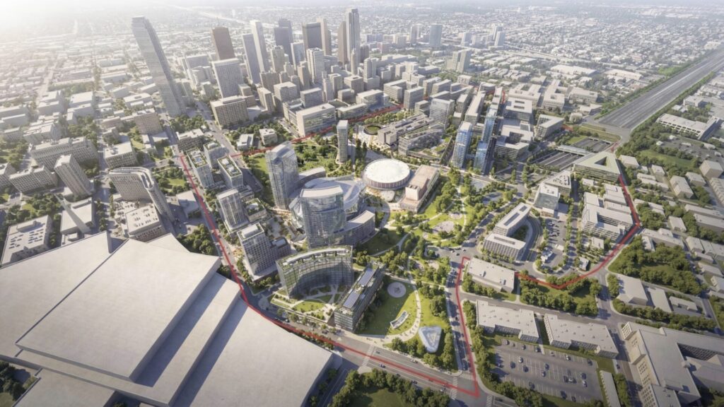
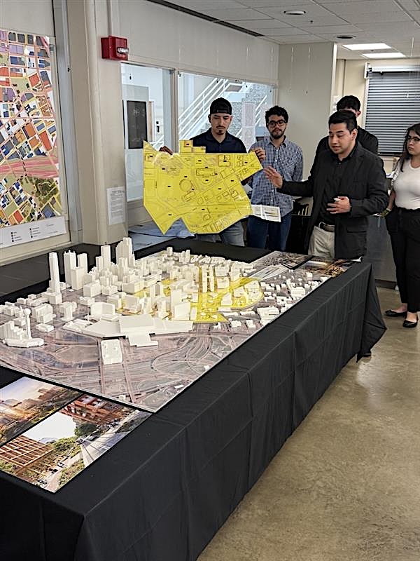
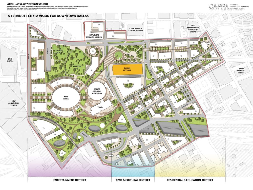
Students from the College of Architecture, Planning, and Urban Affairs at the University of Texas at Arlington (UTA), presented a bold vision for the revitalization of South Downtown Dallas. Designed in the spirit of 15-minute cities, their masterplan took a sensitive approach to a complex site, carefully considering densification, quality of life, new urban connections, and climate resilience.
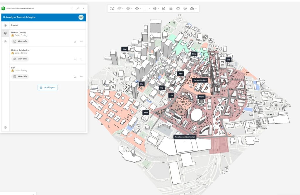
Using Forma Site Design with the ArcGIS integration, the students used environmental and spatial data strategically to analyze the site, make informed early decisions, experiment with more design options, and visualize impacts to better negotiate trade-offs.
Let’s hear more from Eduardo Castañeda, Associate Principal at Arcadis, who co-led the design studio together with Carlos Alba, and Jason Wheeler.
Eduardo, can you tell us about the design brief for this studio?
With the demolition of the convention center in the Dallas Civic District, our primary task was to first understand the site and then propose a design that would revitalize and densify South Downtown Dallas. The large site is currently underutilized, so densifying it required careful placement of different programs such as residential, retail, hospitality, and education.
There were also discussions about demolishing Dallas City Hall, so our secondary objective was to integrate City Hall into our proposal to show that it can remain and function as the heart of the district.
A third objective was to connect the site to the new convention center through a sports arena as an anchor for growth and activity. The proposal included both affordable and luxury housing while maintaining a logical and reasonable vertical building scale.
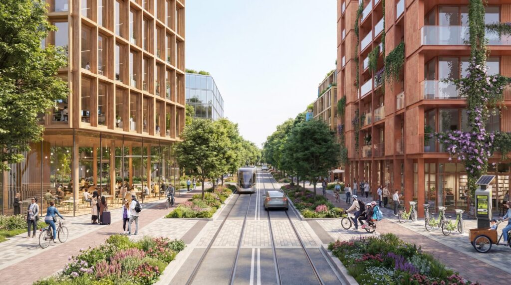
Overall, the studio was framed as a 15-minute city challenge. This meant designing a district – in a car-dependent area – where daily needs such as living, working, shopping, learning, and entertainment are reachable within a 15-minute walk.
What were the main site and design challenges?
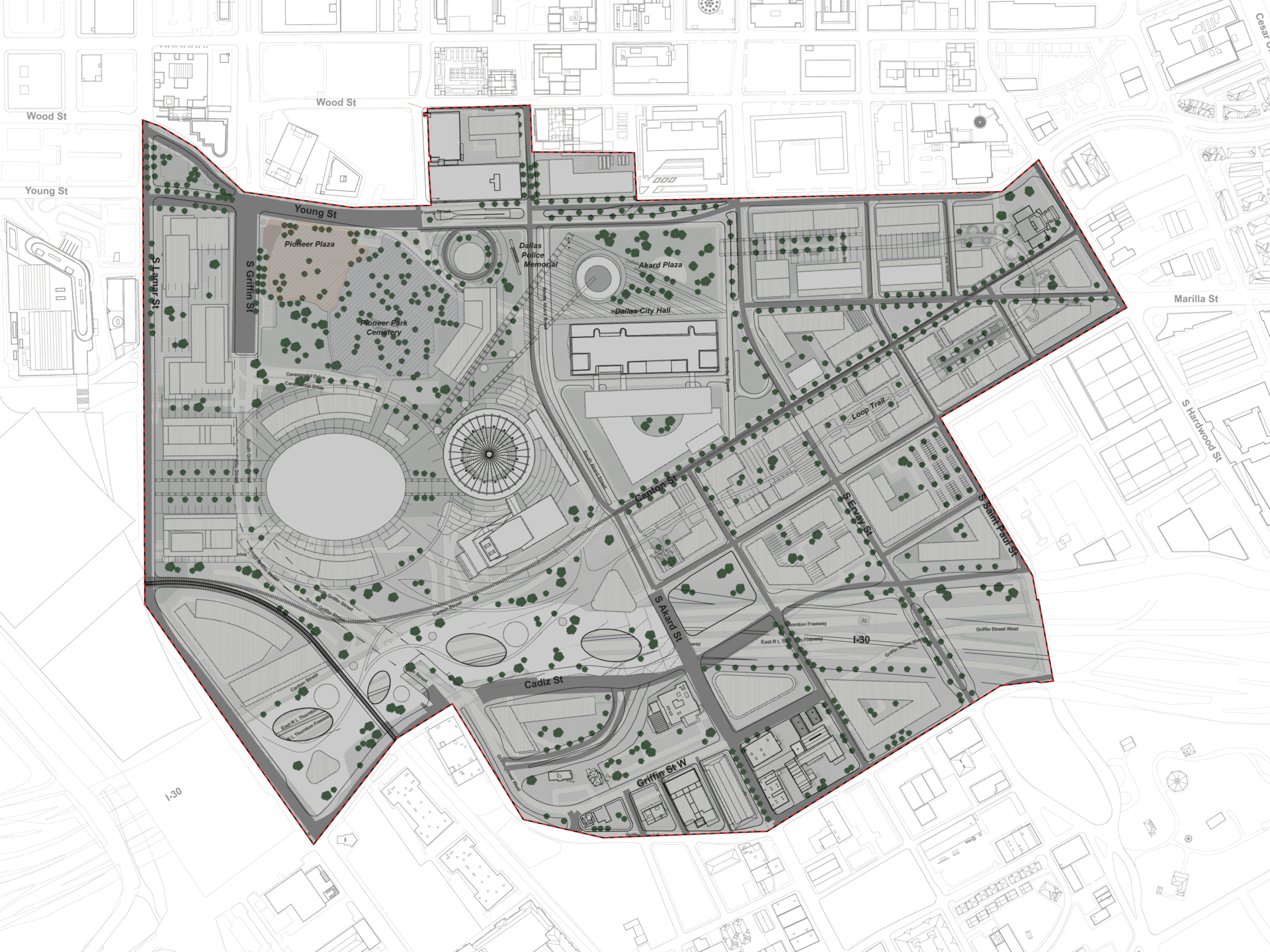
One major challenge was that the site functioned as a blank canvas. While this can seem positive, this made it difficult to establish strong urban connections and avoid fragmenting the civic district. It is also near the Interstate 30 Highway, one of the busiest highway junctions in the United States. This creates a wide physical barrier that separates South Downtown from the surrounding districts.
The students needed to overcome this separation while also introducing meaningful density. At the same time, they were briefed to create a new identity that would activate South Downtown in its own way instead of replicating the character of places like Klyde Warren Park or the Arts District in North Downtown.
How did the students use Forma Site Design to help solve these challenges?
The students were tasked with replicating Arcadis’ data-driven methodology for designing resilient communities that integrates Autodesk Forma Site Design and ArcGIS, starting with site analysis. By adopting this professional workflow for master planning, they gained direct experience with the technical precision required for modern urban design.
When applying this process to the Downtown Dallas Civic Center masterplan, the focus shifted toward creating a vibrant, pedestrian oriented environment. Transforming a historically car-dependent area into a walkable district requires the kind of precision found in our professional practice. The students implemented Arcadis’ approach by focusing on four key shifts in design practice:
- Integrating context from 2D to 3D: Instead of sourcing static 2D maps, the students pulled existing Dallas GIS data directly into Forma Site Design. Working in a live 3D model with layers of real-world data made the urban impacts tangible immediately. They used proximity analysis to verify that their proposed pathways and placements kept the district accessible within a 15-minute walk, actively eliminating dead ends to improve pedestrian connectivity.
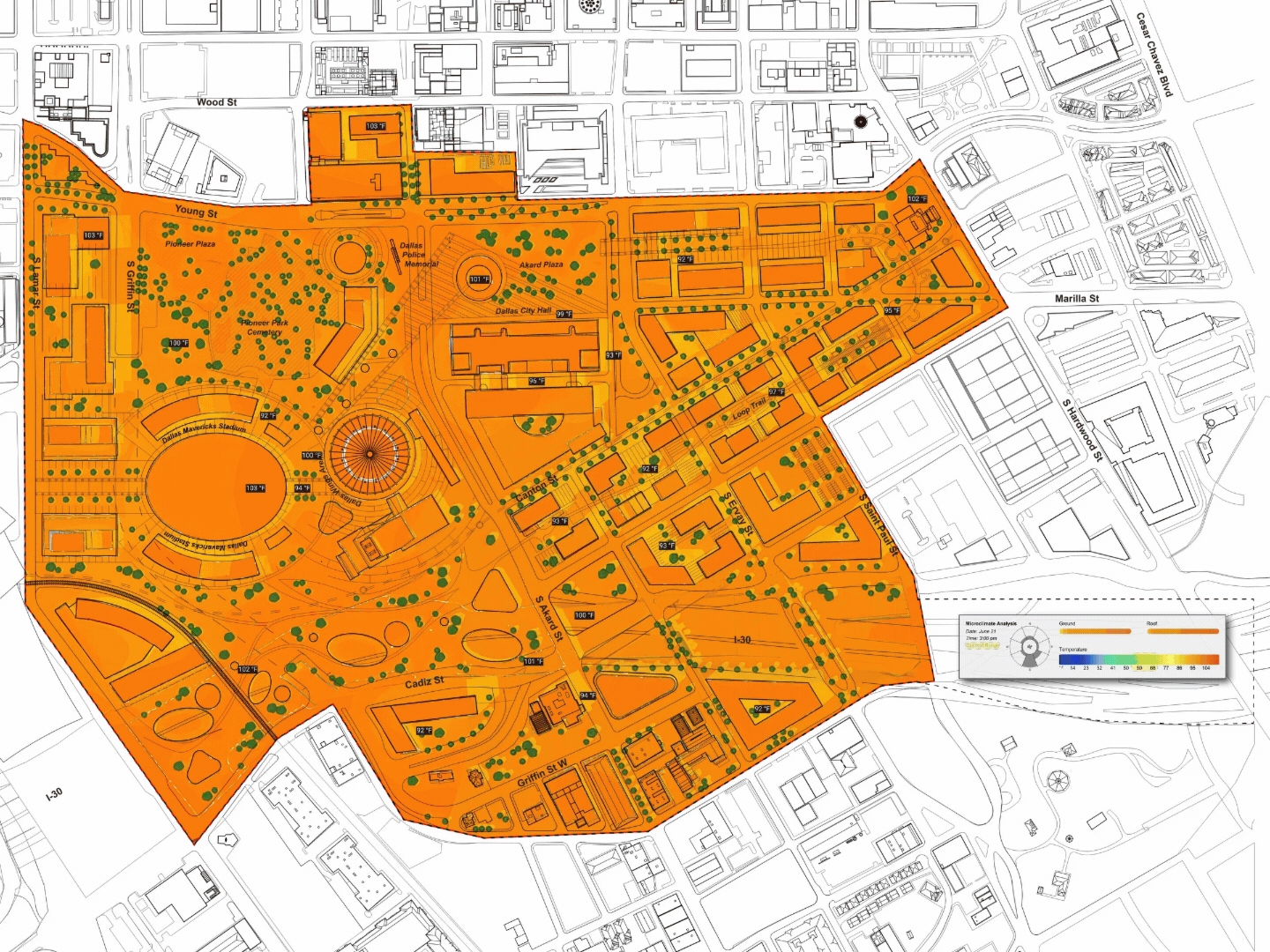
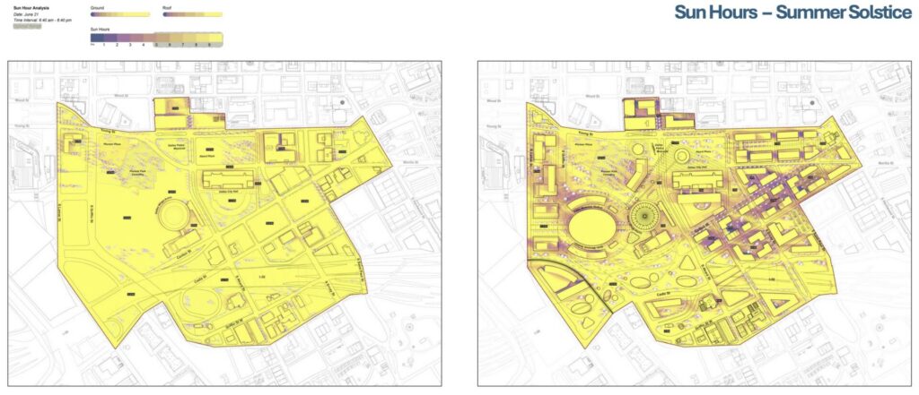
- Moving resilience to the early phase: Knowing that a 15-minute walk in downtown Dallas requires protection from extreme heat, we shifted from a reactive to a proactive design approach. The students ran microclimate, sun hour, and daylight potential simulations from day one. They used this data to sculpt building mass and orientations, intentionally maximizing shade over pedestrian walkways and public plazas to ensure physical comfort year-round.
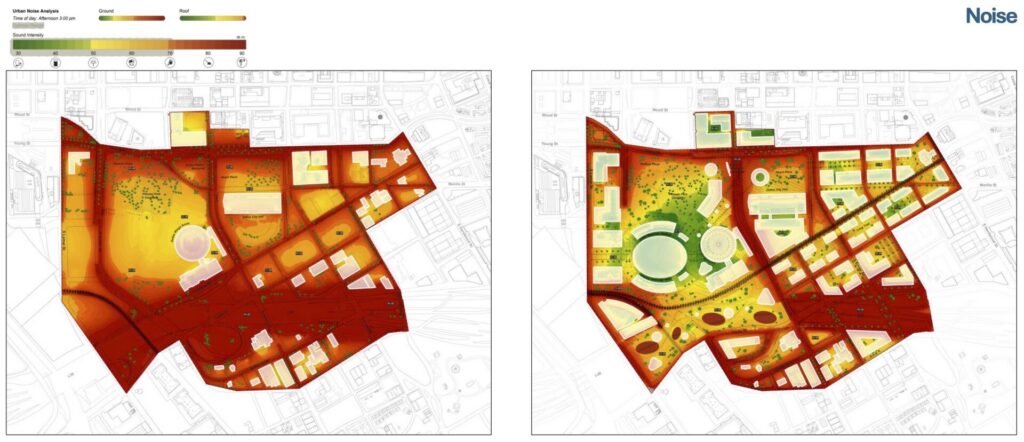
- Enhancing intuition with data: To create a pleasant walking experience near major downtown arterial roads, the students combined real-time environmental and spatial data to make informed decisions earlier. They conducted rapid noise analyses and used this data to strategically position larger buildings as acoustic shields. This allowed them to carve out quiet courtyards and pedestrian zones, protecting pedestrians from street noise.
- Measuring what matters: To transition from the car-dependent layout of the site, the students set context-specific key performance indicators that measure both environmental and social values. They built and compared multiple scenarios side-by-side, using concrete environmental and density data to prove the viability of a walkable civic district over traditional surface parking models.
By highlighting these achievements, the students clearly demonstrated how they moved beyond intuition and used this methodology in Forma Site Design to create a data driven, human-scaled masterplan.
How did using Forma Site Design for site analysis compare to traditional methods?
Forma Site Design was used extensively for analyzing existing site conditions. It helped us understand that many design problems exist in everyday environments but are often overlooked. By studying factors such as noise, sun hours, microclimate, and wind, we were able to clearly see the impact of past design decisions.
Because Forma Site Design provided fast and reliable insights, this made it possible to test new proposals quickly and produce clear visual feedback. Our students could review results together and make immediate design changes. In contrast, traditional site analysis methods often require long periods of data management and post-processing before useful visuals can be created. Using Forma Site Design helped us make data-driven decisions earlier and focus more on creative problem solving.
Also, in traditional studios, we usually focus on smaller sites and individual buildings. Access to Forma Site Design enabled us to work on a larger urban scale. This was a major shift because it allowed us to move from individual building design into urban master planning. The speed of the workflow meant that we could explore more options and develop stronger proposals in a shorter amount of time.
What did you enjoy most about using Forma Site Design during this studio?
As an educator and an Associate Principal at Arcadis, what I enjoyed most was watching the confidence of the students grow as they mastered professional tools and methodologies. When proposing major urban interventions, they must be able to justify their choices. Because of Forma Site Design, they were not just showing polished renderings – they were backing up their urban connectivity strategies and programmatic placements with hard data.
Ultimately, the biggest takeaway for the students was realizing that in urban design, there is no perfect solution. Using Forma Site Design helped them see in real time that it is all about give and take. By testing different massing and environmental scenarios, they learned how to negotiate compromises, figuring out what we are willing to prioritize to find a good, sustainable balance for the city.
All imagery courtesy of the students from the College of Architecture, Planning, and Urban Affairs at the University of Texas at Arlington (UTA).