Autodesk Forma, available in the AEC Collection or as a standalone subscription, offers powerful AI-powered tools for architects and designers in pre-design and schematic design phases.
Autodesk Forma is pleased to introduce the new Terrain Pad tool, now available under the Landscaping tool in Forma Site Design. This enhancement brings terrain editing closer to your design process, making it intuitive and easy to use.
The Terrain Pad tool offers a simple, user-friendly solution tailored for early-stage design, complementing more complex tools like Revit toposolids and Civil3D for later project phases. It provides instant calculations of mass balance, enabling architects to gain insights into terrain related costs early. This terrain editing tool also addresses previous inefficiencies in the Forma terrain tooling by offering a more flexible and intuitive approach, integrated into the design toolbar.
What can you do with the new terrain editing tool?
The terrain pad tool is useful for all those involved in site design and landscape design, and it has a number of key functions.
Freehand drawing
Easily draw terrain pads or pits by defining a polygon and adjusting its elevation. Contour lines with 1-meter resolution provide guidance as you draw. Elevation can be typed in or adjusted in the toolbar when the pad is selected.
Slope adjustment
Define the pad slope as a ratio or percentage, or adjust it manually using a slider. Updates are visualized live in the scene.
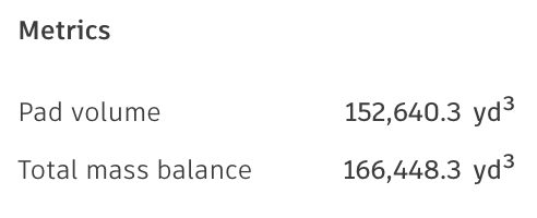
Assess site mass balance
Evaluate both individual pad volumes and the overall site mass balance—the net change in material volume across the entire terrain. Since earthworks are a major cost driver in construction projects, gaining early insight into mass balance enables more accurate cost estimation and helps mitigate terrain planning and design risks from the outset.
The Terrain Pad tool in Forma thus simplifies early-stage terrain editing, allowing architects to make flexible adjustments and gain crucial insights early. Get started with Forma’s terrain editing tool today!